There are areas of Miami-Dade County that most people fly over or drive past without ever really noticing. They are the industrial districts, truck routes, rail yards, cargo terminals, warehouse clusters, rock quarries, and port and airport access corridors that keep the region fed, supplied, housed, and able to build.
Between PortMiami's cranes on the bay and the limestone quarries at the western edge of the county, that overlooked freight landscape becomes visible: Miami International Airport's cargo operations, FEC rail activity, Medley and Doral warehouse districts, expressways, river terminals, industrial land uses, and local truck routes all working together as one freight system.
This project was not my first introduction to freight planning. By the time I joined the study, I had already spent years working on freight issues. What made this assignment different was its scale, specificity, and consequence: the chance to help a major FDOT district begin synthesizing years of freight planning into a countywide strategy for one of Florida's most important logistics markets.
The Countywide Freight Improvement Plan, also known publicly as the Freight Village Analysis Study Countywide, was designed as a capstone to prior District Six freight work. FDOT had spent years developing subarea freight studies for places including Medley, Opa-Locka, Miami River, Doral, Miami Gardens, Hialeah, Homestead, and Monroe County. The missing piece was a countywide effort intended to pull those findings together, test them against current conditions, identify what had advanced, and create a project bank that could support future Work Program decisions.
Prior District Six Studies
The subarea work behind the countywide effort
The countywide study followed eight prior District Six freight efforts that examined the places where freight issues were already being studied in detail. Together, they created the project-bank lineage the countywide effort was intended to synthesize.
 Town of Medley Freight Improvement Plan
2017 | 435754-2-22-01
Town of Medley Freight Improvement Plan
2017 | 435754-2-22-01
 Opa-Locka Freight Improvement Plan
2017 | 435754-3-22-01
Opa-Locka Freight Improvement Plan
2017 | 435754-3-22-01
 Miami River Freight Improvement Plan
2018 | 437946-1-22-01
Miami River Freight Improvement Plan
2018 | 437946-1-22-01
 Doral Freight Improvement Plan
2018 | 437945-1-22-01
Doral Freight Improvement Plan
2018 | 437945-1-22-01
 Miami Gardens Freight Improvement Plan
2019 | 439483-1-12-01
Miami Gardens Freight Improvement Plan
2019 | 439483-1-12-01
 Hialeah Freight Mobility Implementation Plan
2020 | 437949-1-22-01
Hialeah Freight Mobility Implementation Plan
2020 | 437949-1-22-01
 Homestead Freight Improvement Plan
2023 | 437999-1-22-01
Homestead Freight Improvement Plan
2023 | 437999-1-22-01
 Monroe County Freight Improvement Plan
2024 | 443625-1-22-01
Monroe County Freight Improvement Plan
2024 | 443625-1-22-01
I joined as HNTB's Deputy Project Manager for planning-side delivery during a period of project management transition on both the client and consultant sides. The task was to stabilize production, manage evolving priorities, coordinate technical and subconsultant work, and keep deliverables moving while learning a large client, geography, and project history quickly.
For a period, I was the longest-serving person on the project, which made continuity, project memory, and delivery discipline part of the value I provided.
The value was synthesis: helping turn years of local freight studies, stakeholder knowledge, GIS data, policy requirements, and model outputs into a countywide planning foundation for FDOT's next steps.
The Assignment
My first responsibility was helping keep the work organized. Under the meetings and coordination task, our team maintained recurring coordination with FDOT District Six, internal HNTB staff, CTS Engineering, and the public outreach team. I also coordinated public-facing materials, including the FDOT Project Page and Project Fact Sheet, so stakeholders could understand what the study was intended to produce.
The stakeholder program became one of the most valuable parts of the assignment. Our team needed a consistent way to hear from agencies, municipalities, modal operators, and private-sector partners, so I drafted the contact directory and interview guide, prepared background research before each session, and structured interviews around freight challenges, infrastructure needs, and potential solutions.
Those conversations included PortMiami, Miami International Airport, the Miami-Dade TPO and its Freight Transportation Advisory Committee, Miami-Dade DTPW, Florida's Turnpike Enterprise, the Miami River Commission, Antillean Marine, the Miami Downtown Development Authority, private logistics and warehouse stakeholders, and municipalities including Doral, Hialeah, Homestead, Medley, Miami Beach, South Miami, and Sweetwater.
Building the Foundation
The second task gave the study its policy and analytical base. I led a review of at least 28 freight-related plans, studies, and publications, including statewide freight and modal plans, all eight prior District Six subarea freight studies, the Miami-Dade TPO long-range plan, the Miami-Dade County freight plan update, and the master plans for PortMiami and Miami International Airport.
From that review, I helped produce the Document Review Summary Memorandum, a Policy Framework for Freight System Development, a Freight Networks Summary Memorandum, and the Plan Performance Framework. The work tied federal freight policy, FDOT Compass, the Florida Transportation Plan, the Freight Mobility and Trade Plan, the Strategic Intermodal System, and the Five-Year Work Program into one implementation context.
Task 2 Technical Memos
Policy, prior studies, and performance framework
I also drafted the countywide purpose and need statement and a six-goal performance framework tied to FDOT's Compass pillars: communities, safety, resilience, robust supply chain, technology, and workforce development. That framework became the evaluation lens for the recommendations that followed.
Seeing the System
Task 3 translated the policy foundation into a physical picture of the freight network. I led quality management for the Existing and Future Conditions Data Collection Inventory, which organized thirteen GIS data categories, including functional classification, traffic characteristics, truck volumes, level of service, National Highway Freight Network, National Highway System, rail crossings, modal freight infrastructure, land use, demographics, travel patterns, commodity data, and programmed projects.
I authored the Freight and Logistics Network Components Memorandum, documenting the multimodal freight system across roadways, rail, ports, airports, intermodal facilities, industrial land uses, agricultural areas, and rock mining activity. The work described a countywide system that crossed FDOT district boundaries and linked Miami-Dade to Broward, Collier, Port Everglades, SeaPort Manatee, and broader South Florida supply chains.
I also reorganized and heavily edited the Freight Network Performance Overview, aligning it with the plan's goals and performance framework. The memorandum translated traffic, truck-volume, truck-percentage, SERPM, and commodity-flow findings into a usable account of how the freight network was performing and where growth pressures were likely to matter most.
Task 3 Technical Memos
Inventory, network components, and performance overview
From Needs to Action
Task 4 was the most analytically complex. I consolidated 405 multimodal project entries from eleven source documents into a master mobility improvement needs matrix. The database gave our team a common way to organize roadway, rail, and major load-center needs by type, mode, timeframe, funding status, and jurisdiction, while documenting inclusion and exclusion decisions so the methodology could be reproduced.
That project bank became a required input to CTS Engineering's SERPM-supported gap analysis. Our team coordinated with CTS's lead modeler, shared regional growth data for MIA and PortMiami, managed the sequencing between the project database and modeling work, and helped establish timelines for the improvement needs database and integrated freight mobility needs and gap analysis report.
Task 4 Presentation Materials
Needs analysis and project prioritization
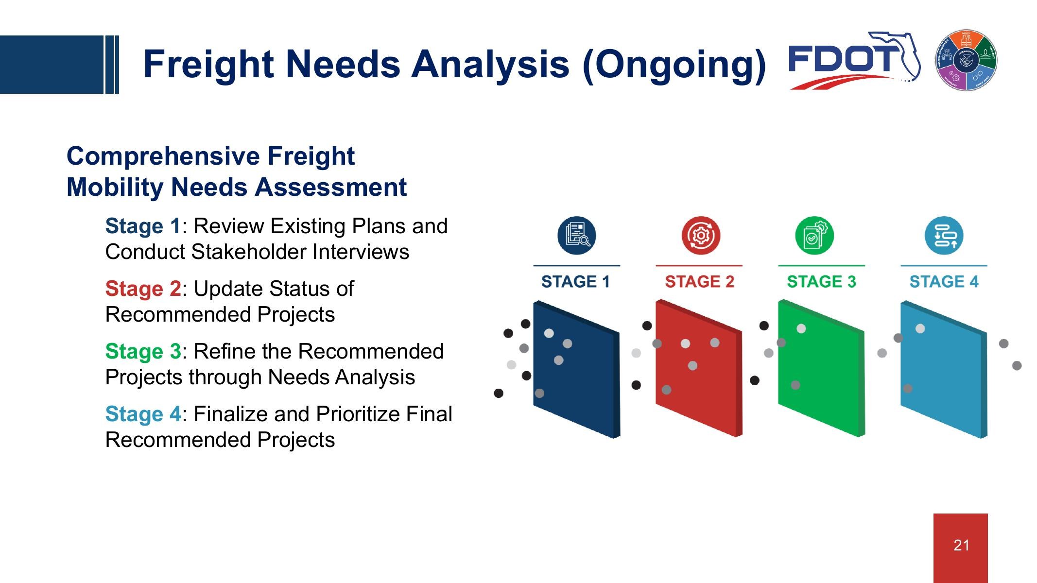
The presentation materials summarized the intended Task 4 flow: review existing plans and interviews, update project status, refine candidate recommendations through needs analysis, and prioritize final recommendations.
Task 5 brought the work closer to implementation. I supported coordination around recommendations from the Monroe County Freight Improvement Study, Northeast 36th Street Multimodal Corridor Study, and Truck Turning Radii Study as they moved toward District Scoping Committee and Electronic Review Comments discussions. That work helped me see the handoff from planning recommendation to scoping, review, and potential Work Program inclusion.
The Value Created
Across the five task work orders, I helped stabilize and advance a coherent countywide freight planning foundation during my time on the project: a stakeholder record, policy framework, freight network inventory, performance overview, GIS data foundation, 405-entry needs matrix, and coordination structure for modeling and implementation strategy. The GIS web application was scoped as a living resource for freight project identification, tracking, grant support, and future project advancement.
My time on the assignment ended before the full needs assessment and final strategy were complete, so the value I am describing is the delivery I helped steady, the technical foundation I helped build, and the work I kept moving through a period of transition.
The work mattered because FDOT District Six already had years of subarea freight knowledge. What the countywide study needed was synthesis: a way to bring that knowledge together, update it, make it comparable, and position it for the investment decisions that determine what gets built.
The assignment also sharpened how I work because it required moving between policy, data, field knowledge, stakeholder input, GIS, modeling, project management, and implementation without treating any one layer as the whole story, deepening my understanding of both the system on paper and the people who use it every day.